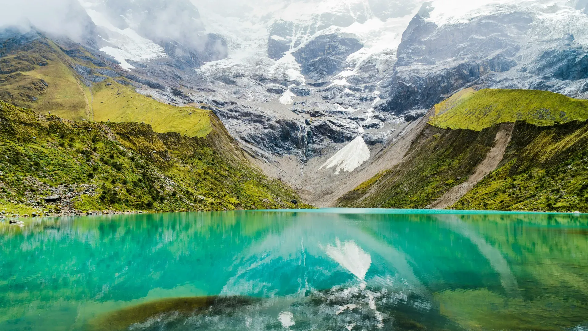
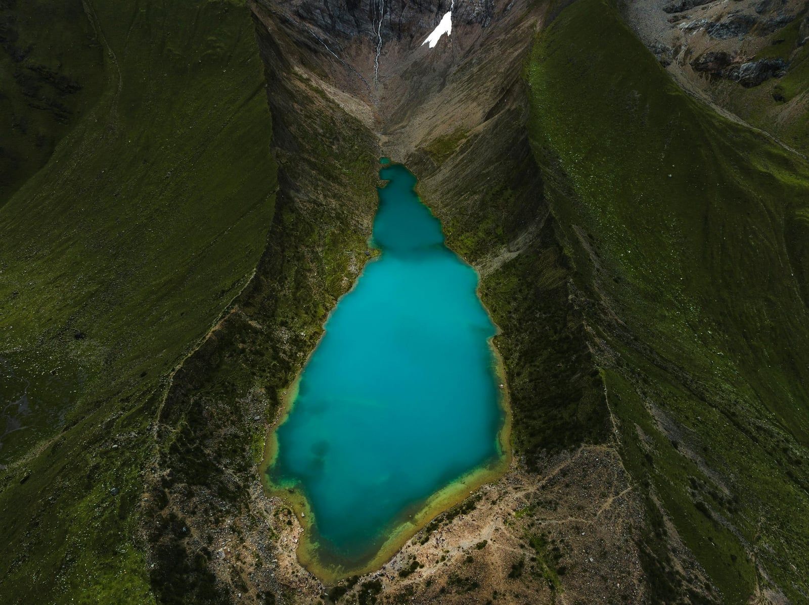
Glacial meltwater forms a turquoise basin at 4,200 meters in the Vilcabamba Mountain Range. Humantay Lake demands a steep 2-kilometer climb from Soraypampa, rewarding hikers with direct views of the 5,473-meter Mount Humantay.
Glacial minerals suspended in freezing meltwater give Humantay Lake its distinct emerald-blue color. The basin sits at 4,200 meters above sea level in the Anta province of the Cusco region. Hikers reach the shoreline after a steep, 2-kilometer ascent from the Soraypampa campsite. The trail gains significant elevation over a short distance. Visitors navigate rocky dirt paths and thin mountain air.
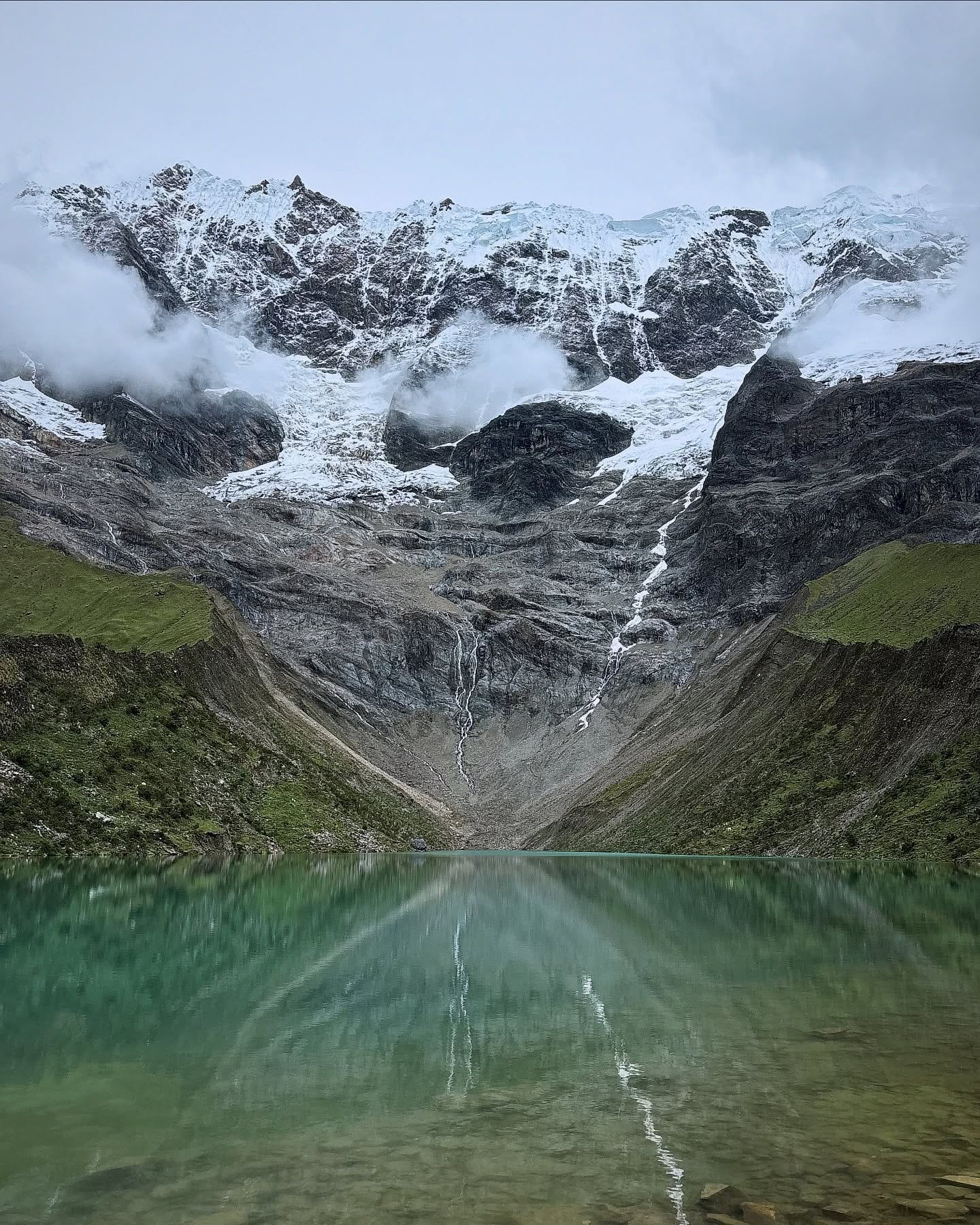
Temperatures at the water's edge hover between 0°C and 10°C. The wind picks up quickly off the surrounding glaciers, cutting through thin clothing. Heavy rain between January and March turns the steep dirt track into a mud slick, frequently obscuring the peaks in dense cloud cover. Clear days between May and October reveal the stark contrast between the bright turquoise water and the white ice fields of Mount Humantay towering overhead.
Day-trippers from Cusco spend roughly 12 to 14 hours completing the journey. The drive covers 124 kilometers and takes three hours each way. Public buses leave Cusco's Arcopata Terminal for 15 soles, dropping passengers in Mollepata. From there, shared colectivos charge another fee to navigate the rutted dirt road to Soraypampa. Private taxis charge around 250 soles for a full-day round trip, waiting at the trailhead while passengers climb. Organized tours cost between 20 and 50 USD, bundling transport, a guide, and meals into a 14-hour itinerary. Visitors pay a 10-sole entrance fee in Mollepata before the paved road ends.
The site acts as the first major milestone for trekkers tackling the multi-day Salkantay route to Machu Picchu. Altitude sickness frequently derails poorly acclimated hikers. Severe headaches. Nausea. Shortness of breath. Spend at least two days in Cusco drinking coca tea before attempting the climb. Carry at least one liter of water per person, as dehydration multiplies the effects of the thin air.
Andean oral traditions trace the lake's creation to a devastating regional drought. Two brothers, Salkantay and Ausangate, left their parched lands to find food and water for their dying communities. Salkantay traveled north, eventually transforming into the massive 6,270-meter peak that dominates the Vilcabamba Mountain Range. Humantay, believed by locals to be one of Salkantay's sons, took form as the adjacent mountain. He shed glacial ice to provide a constant water source for the northern Cusco populations, filling the basin that now bears his name.
The name itself evolved from the Quechua word 'umanapuntay.' Linguistic historians translate this directly to 'the head of the gods' or 'the main head of gods.' Indigenous communities living in the surrounding valleys have recognized this high-altitude basin as a sacred huaca, or shrine, since before the Inca empire expanded across the Andes in the 15th century. They viewed the towering peaks not just as rock and ice, but as Apus—conscious mountain spirits that dictate weather patterns, protect livestock, and control crop yields.
Modern tourism at the lake grew alongside the popularity of the Salkantay Trek in the early 2000s. As the Peruvian government placed strict daily limits on the classic Inca Trail, trekking agencies pushed hikers to alternative routes. The Soraypampa campsite, once a quiet grazing area for local livestock, developed into a major logistical hub. Local residents from Mollepata and Soraypampa adapted to the influx of foreign visitors. They established horse rental cooperatives, built dining tents, and constructed geodesic domes for overnight stays beneath the stars. By 2015, the route saw thousands of trekkers annually. The local economy shifted heavily from high-altitude potato farming to tourism services.
Environmental protections took shape as foot traffic increased from a few dozen trekkers a week to hundreds of daily visitors. Regional authorities banned swimming to protect the fragile glacial ecosystem and the local drinking water supply. Drone flights face strict prohibitions to prevent wildlife disturbance and maintain the site's quiet atmosphere. Wardens actively patrol the shoreline today, confiscating equipment from violators and issuing fines to tour operators who break the rules. Only one toilet exists along the actual hiking path, requiring small coins for entry.
Mount Humantay rises 5,473 meters above sea level, dropping massive sheets of ice into the basin below. The lake forms directly from this glacial runoff. Micro-particles of rock flour, ground down by the moving glacier, remain suspended in the freezing water. These minerals absorb red light and reflect green and blue wavelengths, producing the intense turquoise color visible from the shoreline. The color shifts depending on the angle of the sun, appearing deep emerald under cloud cover and bright cyan at high noon.
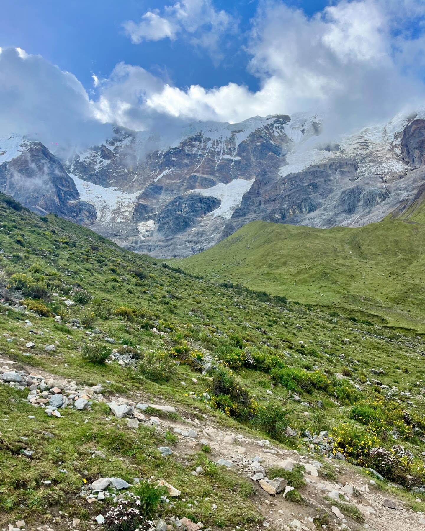
The terrain surrounding the water consists of steep, loose scree and jagged basalt. Hardy high-altitude flora, including ichu grass and low-lying alpine shrubs, clings to the rocky slopes. These plants survive nightly freezes and intense daytime ultraviolet radiation. Vizcachas—small rodents resembling rabbits with long bushy tails—scurry across the boulders near the water's edge. Andean gulls frequently land on the freezing surface. Andean condors utilize the thermal drafts rising from the valley floor to soar above the peaks, boasting wingspans that reach up to 3.3 meters.
The trail from Soraypampa covers 2 kilometers but demands a grueling physical effort due to the 4,200-meter elevation. Hikers face a continuous, steep incline over packed dirt and loose gravel. The path gains roughly 300 meters of elevation in just over a mile. Pure vertical effort. Landslides occasionally block sections of the path after heavy rains in February. The air contains roughly 40 percent less oxygen than at sea level, forcing most climbers to stop every few minutes to catch their breath.
Ultraviolet radiation poses a severe threat at this altitude. The thin atmosphere strips away the natural protection found at sea level, causing severe sunburns in under 30 minutes even on cloudy days. Hikers must apply high-SPF sunscreen and wear wide-brimmed hats. As the sun dips behind Mount Salkantay around 3:00 PM, temperatures plummet instantly. The wind accelerates down the glacier face, dropping the ambient temperature to near freezing before dusk. Renting a horse from the local cooperative at the trailhead costs 90 soles and covers the uphill portion. The horses navigate the rocky switchbacks with ease, but riders must dismount before the final rocky ridge. Trekking poles without metal tips help stabilize hikers on the loose gravel during the downward journey.
Andean shamans continue to perform traditional ceremonies at the water's edge. These rituals honor Pachamama, the earth goddess, and seek safe passage from the mountain spirits before trekkers cross the treacherous 4,650-meter Salkantay Pass. Guides frequently lead groups in a k'intu ritual. Participants hold three perfectly intact coca leaves together, blow on them in the direction of the peaks, and bury them under a stone as an offering. This practice acknowledges the harsh, unpredictable nature of the high Andes and asks the Apus for physical strength.
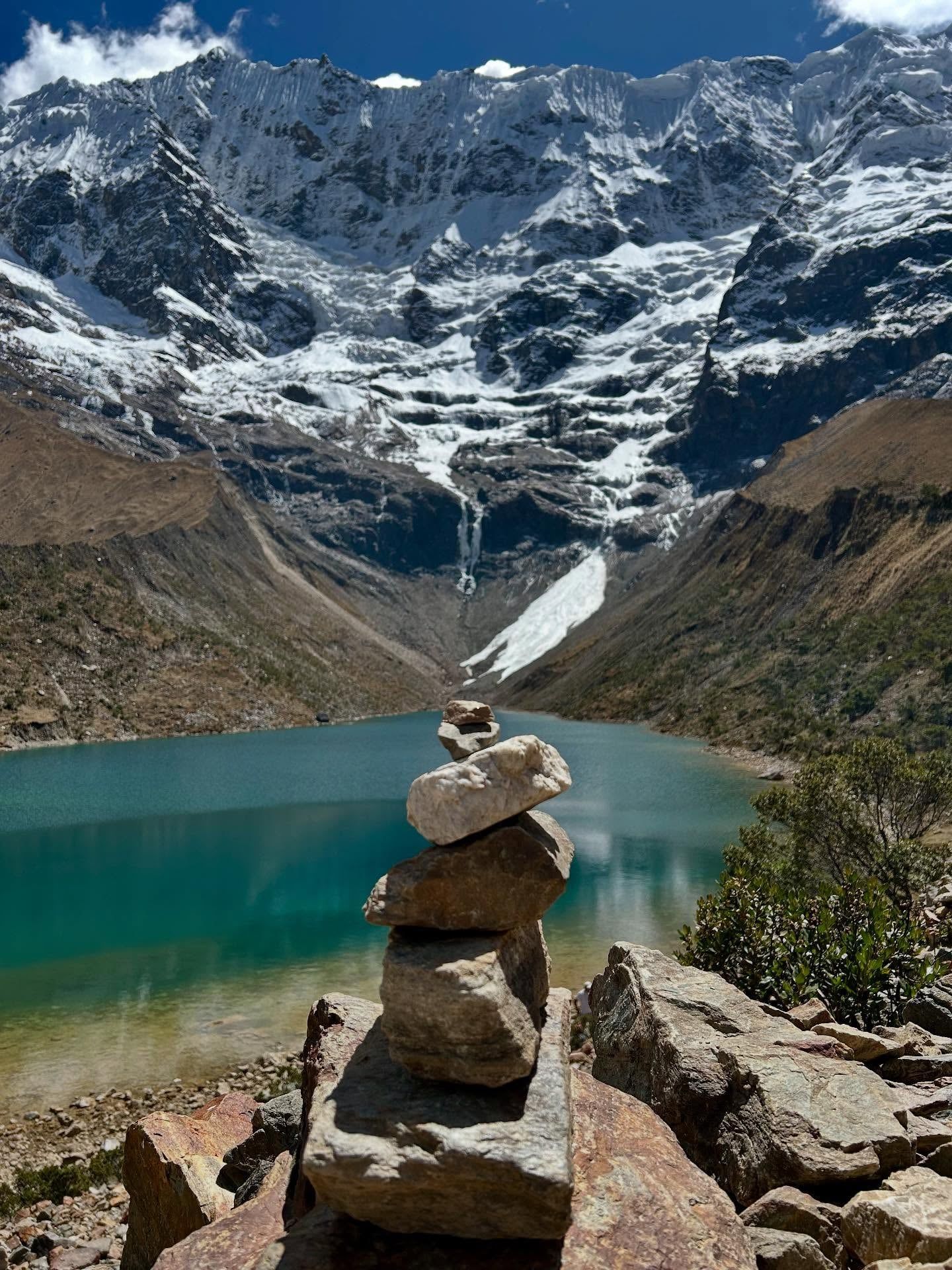
The shoreline is dotted with hundreds of apachetas. Visitors and locals build these small, carefully balanced stone towers to mark their safe arrival and express gratitude. The practice dates back centuries to indigenous travelers navigating the high mountain passes. Disturbing or knocking over an existing apacheta is considered deeply disrespectful to both the builders and the mountain spirits. Park wardens occasionally clear excessive piles to maintain the natural landscape, but the tradition persists daily.
Salkantay translates to 'Savage Mountain' in Quechua, reflecting its frequent avalanches and deadly storms. Humantay represents a calmer, providing force. The dual nature of these two peaks forms a core part of local cosmology. Farmers in the Anta province track the snowpack on Humantay to predict the success of their upcoming potato and quinoa harvests. A dry winter on the mountain signals a coming drought in the valleys.
The lake's water sustains the agricultural terraces in the valleys below. Because it provides the primary drinking source for downstream communities in Mollepata, physical contact with the water carries a heavy taboo. Ropes block access to the immediate water's edge. Respecting these boundaries ensures the glacial runoff remains uncontaminated for the farmers relying on it miles down the mountain. Local laws enforce this cultural boundary, levying fines against anyone caught wading into the freezing basin.
Flying drones is illegal here, with authorities actively confiscating equipment to protect wildlife.
The lake's temperature stays near freezing year-round due to direct glacial melt.
Entering the water is forbidden because it provides drinking water for downstream villages.
The nearby Sky Camp at Soraypampa offers unobstructed views of the Milky Way.
Local community members run a cooperative renting horses for the steep ascent.
The rocky slopes provide habitat for vizcachas and soaring Andean condors.
Visitors traditionally leave three intact coca leaves under a stone to thank the mountain spirits.
The lake sits at 4,200 meters (13,780 feet) above sea level. You should spend at least two days acclimating in Cusco before attempting the hike.
The trail covers 2 kilometers each way from Soraypampa. The steep ascent takes 1.5 to 2 hours, while the descent takes roughly an hour.
No. Swimming is strictly prohibited to protect the glacial ecosystem and the local drinking water supply.
Foreign visitors pay a 10-sole entrance fee, while Peruvian nationals pay 5 soles. This fee is collected in the town of Mollepata.
Yes. Local residents at Soraypampa rent horses for approximately 90 soles. The horses only carry riders up the mountain, not down.
Basic facilities exist at the Soraypampa trailhead, and one basic toilet sits along the path. You must bring your own toilet paper and small coins for entry.
The dry season from May to mid-October offers clear skies and stable trails. Heavy rains between January and March turn the path into thick mud.
Camping directly on the shoreline is forbidden. Hikers must set up camp or rent geodesic domes at the Soraypampa site, 2 kilometers away.
The extreme altitude and cold temperatures make this trail highly demanding for kids. Renting a horse is strongly recommended if you bring older children.
Drone use is illegal at the lake. Park wardens enforce this rule strictly and will confiscate flying equipment.
Browse verified tours with free cancellation and instant confirmation.
Find Tours